Home
Otok Hvar
O otoku Hvaru
Mesto Hvar
Jelsa
Stari Grad
Basina
Ivan Dolac
Milna
Sveta Nedilja
Vrboska
Zavala
Sućuraj
Uvale v otoku Hvaru
Privatna namestitev
Apartmaji Jelsa
Apartmaji Milna
Apartmaji Vrboska
Apartmaji Zavala
Apartmaji Basina
Apartmaji mesto Hvar
Apartmaji Stari Grad
Apartmaji Ivan Dolac
Apartmaji Sveta Nedilja
Apartmaji Sućuraj
Apartmaji pogled na morje
Apartmaji ob morju
Počitniške hiše
Hiše, apartmaji z bazenom
Poceni apartmaji
Kako dopotovati
Kako priti do Hvara
Trajekti za Hvar
Taxi prevoz z ladjo
Zemljevidi Hvara
Zemljevid otoka Hvar
Zemljevid mesta Hvar
Zemljevid Jelsa
Zemljevid Stari Grad
Mapa weba
Kontakt
Otok Hvar
Iskanje namestitev
datum
code
Prihod
Odhod
1
2
3
4
5
6
7
8
9
10
11
12
13
14
15
16
17
18
19
20
21
22
23
24
25
26
27
28
29
30
Osobe
U više od jedne jedinice
Otok Hvar
Mesto Hvar
Stari Grad
Jelsa
Sućuraj
Vrboska
Zavala
Ivan Dolac
Sv. Nedilja
Milna
Basina
Mudri Dolac
Zaraće (Hvar)
Zastupac (Hvar)
Jagodna (Ivan Dolac)
Bojanić Bad (Ivan Dolac)
Tatinja (Stari Grad)
Prapratna (Jelsa)
Grebišće (Jelsa)
Vela Stiniva (Poljica)
Pobij (Gdinj)
Rapak (Gdinj)
Pokrivenik (Gdinj)
Srhov Dolac (Gdinj)
Torac (Gdinj)
Tvrdni Dolac (Gdinj)
Vela Lučica (Gdinj)
Zavala (Gdinj)
Zarace (Gdinj)
Virak (Gdinj)
Skozanje (Gdinj)
Bristova (Bogomolje)
Solotiša (Bogomolje)
Pogorila (Bogomolje)
Smokvina (Bogomolje)
Otok Hvar
Šifra objekta:
(Npr. za apartma A-4047-a upišite 4047)
Hvar info
O otoku Hvaru
Plaže na Hvaru
Slike Hvara
Klima otoka Hvar
Vremenska napoved
Aktivnosti
Nočno življenje
Kaj videti?
Restavracije na Hvaru
Kako dopotovati
Kako priti do Hvara?
Trajekti za Hvar
Zemljevid otoka Hvar
Transfer lodí
Jadranje na Jadranu
Najem jadrnic
Najem jadrnic
Marinas:
Marina Kastela
,
Trogir
,
Dubrovnik
,
Split
Otok Hvar, Hrvaška
Vremenska napoved
Sobe in apartmaji - otok Hvar 2026!
Apartmaji, sobe Hvar
- Hiše, apartmaji in sobe za oddajanje - otok Hvar - total 630 namestitev! -
Velik izbor, znižane cene, komentarji gostov!
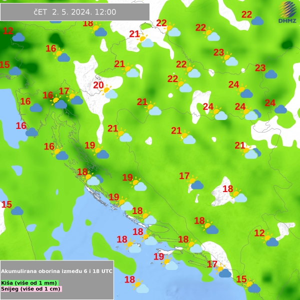
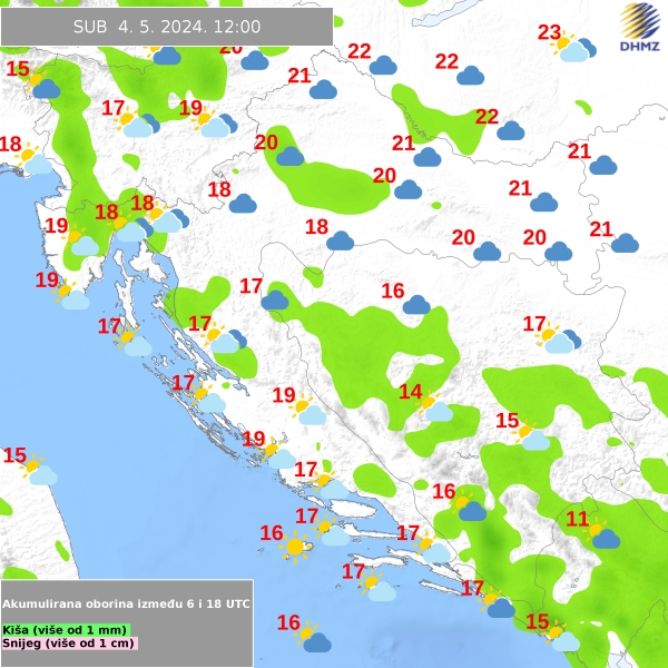
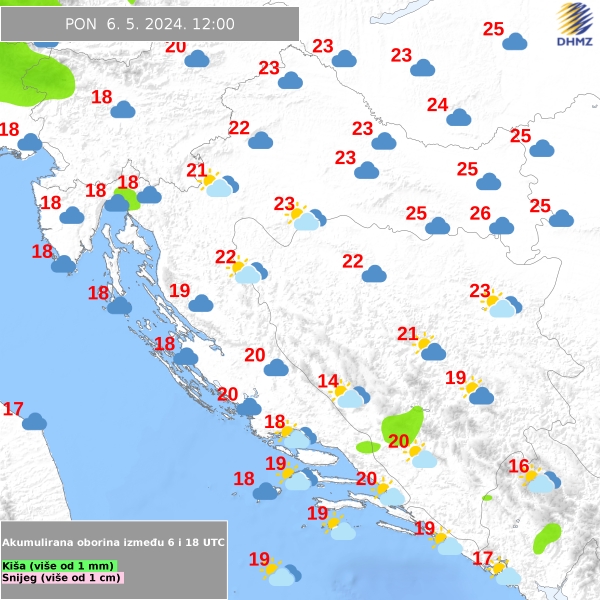
Vremenska napoved
Vremenska napoved Hrvaška, vremenska mapa:
tomorrow
2 days
3 days
4 days
Hvar info
O otoku Hvaru
Plaže na Hvaru
Slike Hvara
Klima otoka Hvar
Vremenska napoved
Aktivnosti
Nočno življenje
Kaj videti?
Restavracije na Hvaru
Kako dopotovati
Kako priti do Hvara?
Trajekti za Hvar
Zemljevid otoka Hvar
Transfer lodí
Jadranje na Jadranu
Najem jadrnic
Najem jadrnic
Marinas:
Marina Kastela
,
Trogir
,
Dubrovnik
,
Split
Otok Hvar
Mesto Hvar
Ivan Dolac
Stari Grad
Sv. Nedjelja
Milna
Zavala
Jelsa
Basina
Vrboska
Sućuraj
Uvale v otoku
Vreme na Hvaru
15.8 °C
1006 hPa
7 km/h
Temperatura morja:
18.0 °C
Vremenska napoved
Apartmaji, sobe, hiše
Počitniške hiše
Hiše, apartmaji z bazenom
Poceni apartmaji
Apartmaji pogled na morje
Ob morju na plazi
Apartmaji Jelsa
Apartmaji Hvar
Apartmaji Stari Grad
Apartmaji Milna
Apartmaji Ivan Dolac
Apartmaji Vrboska
Apartmaji Zavala
Apartmaji Basina
Apartmaji Sveta Nedilja
Apartmaji Sućuraj